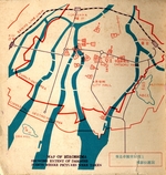
Map of Hiroshima, Showing Extent of Damages and Points Where Pictures Were Taken
Dublin Core
Title
Map of Hiroshima, Showing Extent of Damages and Points Where Pictures Were Taken
"Hiroshima Photograph"
Description
Illustrated with 24 actual mounted photographs. Upper wrapper with schematic design of an atom in red, white, and, blue on a purple ground, rear wrapper with map of Hiroshima. Includes original prints of 2 of the very few known photographs taken in Hiroshima on the day of the bombing.
Creator
Hiroshima Peace Society.
Publisher
Hiroshima Peace Society.
Date
October 1, 1949.
Format
6 leaves. Small 4to, decorative wrappers.
Language
eng
Identifier
0353
Collection
Citation
Hiroshima Peace Society., “Map of Hiroshima, Showing Extent of Damages and Points Where Pictures Were Taken,” Special Collections & Archives Research Center, accessed January 4, 2025, http://scarc.library.oregonstate.edu/omeka/items/show/1401.

